Overall, I walked 15.1 miles on Sunday, making the January totals 98.9 miles. Had I known I was so close to making a 100 miles in the month, I would have soldiered on. But my ankle and my back, as a result of tripping up on the 21st and then walking on all that snow, were really killing me.
And I fell into all the landmarks in Lexington and 65th-67th and had just to photograph them. The Lexington Avenue side of the Seventh Regiment Armory finally has its scaffold off, so that was a treat. Unfortunately the scaffolds went up on St. Jean the Baptist church.
February has four weekends, so my goal is to cover 80 miles in the month. If it keeps snowing, I'm going to have to limit myself to Manhattan (south of 96th Street, apparently). If not, I'll take a stab at the Bronx.
I really want to go to Staten Island (the landmark status for four structures in Rossville is being considered today), but until we get 12 hours of daylight (i.e., after March 18th), it's not worth the trek.
Tuesday, February 1, 2011
Sunday, January 30, 2011
Getting the two letters ready
Today's walk went fine, considering I was trying to avoid the snowy sidewalks, up until I made it to the Bronx. Bruckner Boulevard was pretty much passable on its Western side, but on the Port Morris portion it was very messy. The southern sidewalk disappeared under a pile of snow near the Hess gas station.
And then I made my first mistake. Since the Willis Avenue Bridge is being replaced, its pedestrian walkway has been closed (or rather, removed.) So I decided to cross over the RFK-Triboro Bridge. The stairway on the Bronx approach was a complete mess, and then the walkway on the bridge itself was completely covered in snow.
A smarter, sensible person would have turned around right then and there, but since I'm pretty stubborn and an optimist, I kept on through, without snow boots. Somehow I made it to the other side with just a very wet pair of walking sneakers.
I don't like walking in Randalls Island for many reasons, mainly because its an environment unfriendly to pedestrians, and the complete prohibition of photography doesn't help.
The Manhattan approach was a little bit better, having its walkway shoveled. But I almost stepped on a banana peel, no less.
From Second Avenue I decided to take the East River Promenade at 114th, which was a second mistake. The pedestrian bridge and the promenade had not been shoveled up until...wait for it...96th Street. This is not only bad, but what kind of message does it send? The same amount of people live north of 96th than south, as it relates to this promenade. Disgraceful.
So I'm getting the two letters ready.
Saturday, January 29, 2011
So Manhattan it is
I had grand walking plans for this Sunday, combining Manhattan, the Bronx and Queens. But then I realized that if many sidewalks in Forest Hills were still difficult to walk, it couldn't be much better in other parts of the borough.
I twisted my ankle (in the softer, more general way of the verb twist) again on Thursday, but it seems to be behaving better. But I'm not going to chance it by doing cross-country snow walks.
So I'll just walk in Manhattan on Sunday, maybe around the edges. By the way, if it snows again on Tuesday, where is all of it going to go? We don't have any place for it.
Tuesday, January 25, 2011
Shooting photos at the HH Bridge
One of my pet peeves as a walker and photographer is places that forbid photography in the outdoors. The biggest culprit by far is the Triborough Bridge and Tunnel Authority, a part of the MTA. Last June they reopened the Henry Hudson pedestrian walkway, and when I crossed it, I noticed that photography was strictly forbidden.
After an exchange with one of their representatives, I was a little surprised to see this video:
After all, according to what spokesperson Joyce Mulvaney told me, "activity by a photographer on the Henry Hudson Bridge walkway carries the risk of distracting drivers crossing the bridge in the immediately adjacent traffic lane."
So I guess their video operation did not distract any drivers. Good for them.
Monday, January 24, 2011
Geocommons
I'm not too sold on Geocommons, a mapping application which is free to use. I am still going to use Google Earth for most things, but I do like how it mashes up data and how it combines KMLs with Shapefiles.
Below is a map of my walks along with a map of the NYCLPC designated landmarks (and some pending ones, too). If you poke around it's obvious how I tailor most of my walks around landmarks.
View full map
Below is a map of my walks along with a map of the NYCLPC designated landmarks (and some pending ones, too). If you poke around it's obvious how I tailor most of my walks around landmarks.
View full map
Saturday, January 22, 2011
Out of commission
On Friday, I took some time off from work and went to Central Park to shoot the snow. Very nice photos, but I tripped twice. First time around, mildly twisted my ankle after making a full stop as to not invade a photographer's field of vision. The second time was in the Bramble Bush, going downhill. Ouch. I walked 6 miles but had to call it quits.
Tuesday, January 18, 2011
Some stats for this year
After Sunday's walk, here are some stats. I walked 22.1 miles on Sunday (that includes the distance from the subway station to my place as I got back from the UWS). That makes it 76.1 miles so far this year (in kilometers it looks even more impressive: 122.4).
At this time last year, I had only covered 27.6 miles, so that's great. Hopefully I can keep it up in the spring.
The updated map with all the walks is here, and hopefully I'll embed my table with all the walks pretty soon.
At this time last year, I had only covered 27.6 miles, so that's great. Hopefully I can keep it up in the spring.
The updated map with all the walks is here, and hopefully I'll embed my table with all the walks pretty soon.
Monday, January 17, 2011
Jan 16: Walking for distance
I really slow down when I take a bunch of photos. It's ironic, since I do walk because I want to photograph things and people, but last week's walk was truly hampered by all the photos.
So I planned this walk in more distant places that had less to photograph, or at least that would make me go faster. It wasn't too cold, but I hit a good stride early on (snow in the sidewalk or not), covering 10 miles in four hours; excellent pace for me. By 1:10 p.m. I was at the Williamsburg Bridge, and it was all peachy. Hit Verdi Square by sunset.
My two detours were by proposed NYCLPC landmarks, Central Ridgewood Historic District, and two buildings in the Bowery. I then hit Prince Street and eventually 9th/10th Avenues and never looked back.
I hopped in the subway at Broadway and 96th at around 5:20 p.m, got home in Forest Hills by 7.
You can see the whole map here.
Sunday, January 16, 2011
I would have walked more...
...were it not for the damn snow. I got up early, was out the door before sunrise and despite a very long walk, the snow was thick and heavy along Union Turnpike. The first couple of miles by the sidewalk were bogged down. There's a stretch of sidewalk, by Union Turnpike and Woodhaven Boulevard that was completely covered in snow. I had to hit the street and hope for the best.
Once I got to Brooklyn, hit rough patches in the easternmost part of Eastern Parkway, where ice had accumulated. I know that these parts of town are not too pedestrian friendly, but then again, these are major thoroughfares that had problem sidewalks, four days after the snow storm (and I'm guessing the accumulations were there by December 26.
Unsurprisingly, Manhattan was much better, but there's a sidewalk full of snow by Clinton and Delancey.
I guess that's what I deserve for walking in January.
Monday, January 10, 2011
The bridges of NYC counties
One of my pet projects to discover "the real new York" back in the summer of 2008 was to cross all the major bridges of the city. While there may be disagreement as to what a major bridge is, I'm pretty confident that I've crossed all the important bridges opened to pedestrians in New York City.
I really like the spectacular views from both the George Washington and the plain old Washington bridges. And the Marine Parkway Bridge and Bayonne Bridge also hold a dear spot in my heart. But my favorite, after a walk yesterday reminded me, is still the Brooklyn Bridge. There's something about it, with its elegant arches, magnificent view and span cables that make it breathtaking every time I cross it.
True, if I had to ride a bike accross it I would probably have killed many-an-interloping-tourist by now. But despite them, it truly never ceases to awe.
January 9, 2011 walk
Overall, despite some really bad ice situations in the pedestrial walkway of the Queensboro Bridge and, surprisingly, on West Avenue in Manhattan, the walk went pretty smoothly.
I was almost run over by a parking meter vehicle which was heading back to the Tenderloin precinct driving the wrong way on West 30th Street, but it was a minor inconvenience. I discovered the Chelsea West district and was also impressed by the sunset as I was walking across the Manhattan Bridge back to Manhattan.
Totals: 20.3 miles (19.85 in one stretch). So far this year I've walked 53.9 miles. High temperature was 32 degrees, and the wind chill was under 20 degrees most of the afternoon.
Sunday, January 9, 2011
Snow and other disasters
Just crossed the Queensboro bridge, and the snow on the pedestrian Walkway on the Queens side is pretty tricky.
Will do Midtown and Hudson River park today, wind was nasty on the bridge, but I guess it can't get worse.
Will do Midtown and Hudson River park today, wind was nasty on the bridge, but I guess it can't get worse.
Friday, January 7, 2011
Why it takes me forever and a day to upload photos
When I go out on walk, I'm not like professional photographers, who take good photographs after analyzing the angle and studying the area and pose. I'm pretty much a point-and-shoot guy, and once I get home to take a good look at the photos, it shows.
And unlike good photographers, my photos go up in Flickr on a pass/fail basis. I very seldom if ever retouch them. Having said that, there are other rituals I follow once I get home from my walks.
1. Map my hike. I'm very interested to know I've walked, so I plot it out in Gmaps Pedometer. Once I have the total, I add it to a spreadsheet and then create a path in Google Earth, which allows me to produce pretty maps like this one.
2. Send all the photos to the panorama manager, which stitches them. I use Autopano Giga to saw up photos like this one or more complicated shots like this one. I do have a fisheye but seldom use it.
3. Once the panoramas are rendered, I start the tagging and keyword process. I use iTag, an invaluable windows program. I am a tagging fiend, and like adding several keywords to my photos (see example here).
4. If it involves a NYC Landmarks Commission designated property, I use the designation report. I started scanning the PDFs late in 2009 and adding them to my photos. Some reports are either intelligible or scribbled over but most are legible to a degree. But for example, on Tuesday I photographed eight landmarked theaters so I had to go over the reports for each of them, and I'm still not done.
5. Geotagging. I used Picassa to geotag my images, but somewhere along the way its geotagging stopped playing nice with Flickr's finicky upload process and the photos were rejected during upload. So I now use Geosetter, which along with iTag prevents me from doing all of this on a Mac, since both valuable tools are Windows-only.
6. Once I do all that, I go back and look at the photos one by one. I select the ones I like and upload them. Usually 15 percent of all the photos I've taken make it into Flickr.
This usually takes days, considering I work full-time and a 40-hour workweek is a pipedream. It's what separates a hobby from a passion.
Thursday, January 6, 2011
Mapping it through
I am, at heart, a map geek. I've loved detailed maps since I was a kid, and my map collection, somewhere in a storage bin in Miami, amounts to the thousands. So it shouldn't be strange for me to actually map every walk I've taken in New York City. Following is the Google Earth image of all my walks:
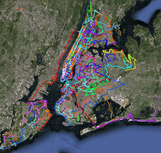
You can see the map above in Google Maps.
If you notice a small orange strip on the top left hand side, that's a walk in Paterson, New Jersey. I was going to walk from there to Newark through the Lenape Trail. But I was really under the weather that day and limited the whole day to the Great Falls of the Passaic.
When you see this map, keep in mind that this obviously doesn't take into account non-walks. Which is to say, I've been to Sheep Meadow, the Village and many, many other locations countless times.
But I wasn't in a long walk, so that's not on the map. I was looking at Gantry Plaza State Park, one of my favorite locations in NYC, and of course, I was wondering why I've only been there once. Of course, I haven't. But it's only been part of a bona fide walk a couple of times.
View Larger Map
Wednesday, January 5, 2011
Queens' smaller cemeteries
Per capita, Queens has more cemeteries than any other borough (although Staten Island is gaining ground with the Cemetery of the Resurrection). The larger ones like Calvary are fairly easy to see from the BQE and many parts of Hunter's Point and Maspeth, but it's the smaller ones, tucked away in corners sometimes, that I really like.
Prospect Cemetery, by the LIRR tracks in Jamaica, is one of the oldest, with graves going back to 1709. It's part of York College, so there is no access on weekends and holidays.
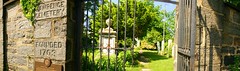 Two years ago, I bumped into the owner of the Lawrence Family Graveyard in Steinway. It's a private cemetery, and even though he married into the family, the man is doing a great job with the upkeep. He was nice enough to let me in and shoot some pictures. Major Thomas Lawrence was first buried here in 1703. If you go, try to arrange your visit with the owner (who lives next door), otherwise you won't see a whole lot from the street.
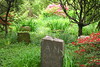 A couple of miles southeast, the Moore-Jackson is tucked in between a couple of buildings. During the spring and summer, the trees and shrubbery run amock, giving it quite the wild look. Even though it's more impressive then, you can see the whole graveyard during the winter months.
I could go on and on, and I will. Don't forget to check out the other Lawrence cemetery in Bayside, Flushing Cemetery, the Cornell Graveyard in the Rockaways (do arrange a tour for this one because you won't be able to see zilch from the street). And if you want to see a mini-cemetery, check out cozy Remsen Cemetery near Yellowstone Blvd on Trotting Course Lane in Forest Hills.
Prospect Cemetery, by the LIRR tracks in Jamaica, is one of the oldest, with graves going back to 1709. It's part of York College, so there is no access on weekends and holidays.
Two years ago, I bumped into the owner of the Lawrence Family Graveyard in Steinway. It's a private cemetery, and even though he married into the family, the man is doing a great job with the upkeep. He was nice enough to let me in and shoot some pictures. Major Thomas Lawrence was first buried here in 1703. If you go, try to arrange your visit with the owner (who lives next door), otherwise you won't see a whole lot from the street.A couple of miles southeast, the Moore-Jackson is tucked in between a couple of buildings. During the spring and summer, the trees and shrubbery run amock, giving it quite the wild look. Even though it's more impressive then, you can see the whole graveyard during the winter months.I could go on and on, and I will. Don't forget to check out the other Lawrence cemetery in Bayside, Flushing Cemetery, the Cornell Graveyard in the Rockaways (do arrange a tour for this one because you won't be able to see zilch from the street). And if you want to see a mini-cemetery, check out cozy Remsen Cemetery near Yellowstone Blvd on Trotting Course Lane in Forest Hills.
Riverdale to 42nd Street
I knew it wasn't going to be pretty with all the ice, and in some spots it really wasn't. Despite having a few close calls here and there, Tuesday's walk went off mostly without a hitch.
Took the early F train to Bryant Park, and from there walked to Grand Central Terminal. The 6:50 to Crotona dropped me off at Riverdale, and there I began my walk.
As expected, the lack of sidewalks in many parts of northern Riverdale (namely Sycamore and Independence Avenue north of 246th made walking on the snow quite tricky. Thankfully there wasn't much traffic, and I made it off fine.
I always get spooked while photographing and walking in Riverdale. Between its many private streets (some of which don't ban trespassers outright) and antsy residents (one of them berated me a few months back because I dared take pictures of the houses), it's no picnic. Yet it's one of the most suburban and beautiful neighborhoods the city has. More on that on another post.
The most slippery part of the journey was in the parks and bridges. Henry Hudson park was just lightly plowed, and the pedestrian access to the Henry Hudson Bridge was full of icy snow. I don't know why the TBTA spent all that money refurbishing the walkway if they are not going to plow the Sputyen Duyvil end for over a week.
Once in Inwood Park, the pathways were reasonably paved, but for a few stretches in which yours truly almost fell on his ass. Once on Broadway, it was just beautiful. I did make my stop at El Malecón for a delicious Sancocho (the menu's bland translation calls it Caribbean Soup, but it's really more like a leftover concoction. I usually frown on eating too much during walks, but I didn't regret it.
I made it down to the Time Warner Center, and no surprises there. Plenty of tourists and down in Whole Foods, packed to the hilt. I estimated the 10-items-or-less line was 5 minutes long. Really, people?
Once in 46th Street I made use of my monopod, taking some night-time pictures of the Ambassador Hotel and the theaters on Shubert Row and Alley. Subway was packed, but made it home in 20 minutes. All in all, a little over 16.5 miles. If you look at it on a map, it's a pretty straight line.
Tuesday, January 4, 2011
Back to the Bronx
January is probably the best time to photograph some of the estates in Riverdale, and that's where I'm headed this morning. After spending most of the summer and the fall walking in Queens and Brooklyn, nice to be back to the Bronx, even if it's just to see the same things all over again.
Once there I'll take the fairly new pedestrian walkway over the Henry Hudson Bridge and from there into Inwood, the Heights and then down Broadway to Midtown. In Washington Heights, I'll make a pit stop at El Malecón for some great Dominican food. It's funny, because I live over 15 miles from that restaurant and I must have visited it ten times in the last two years.
What I don't look forward to is Independence Avenue, which is incredibly unfriendly to pedestrian in its northern reaches. With the snow it's not going to be a picnic.
I'm still working on Sunday's pictures, some should be up by tonight.
Monday, January 3, 2011
Why were all the bathrooms closed?
I have enough customer service experience to know that the difference between a reasonable request and coming across as a complete nut job could be quite thin. I don't particularly like writing complaints because more often than I get the same bland response. However, I had to complain about the bathroom situation yesterday.
If you plan to walk several miles in the city, you must either have a bladder made of steel, don't mind going to Starbucks and other private venues or rely on public restrooms. OK, there's a fourth choice which I won't mention. The last option, however, is haphazard at best in New York City, where the parks are chronically underfunded (except for the deluxe bathroom at Bryant Park, which has to cost a pretty penny to maintain.)
Yesterday, I tried my luck going to seven different bathrooms. It was a Sunday, not the ideal day to go to the parks, but as weather goes in January, 53 degrees isn't too shabby. Shockingly, the seven bathrooms I tried to visit were all closed.
Thankfully the restrooms at Costco and Gantry Plaza State Park were fully functional.
I wrote the following complaint to the Parks Department, with a copy to a couple of council members. The former have been pretty good in at least addressing my complaints in the past, so I'll update with their response.
As a taxpayer, I was deeply disappointed and upset to find the bathrooms closed in eight different parks and playgrounds yesterday, Sunday January 2. Were people not supposed to visit park this Sunday? I would like an explanation as to why all these parks had their bathrooms shut down.
Here are the parks and the time I found out they were not open to the public:
Ditmars Park - 9:40 a.m. CLOSED
Woodtree Playground - 10: 25 a.m. CLOSED
Charybdis Playground, Astoria Park - 11:30 a.m. CLOSED
Hallets Cove Playground - 12:14 p.m. CLOSED
Socrates Sculpture Park - 12:30 p.m. CLOSED
Rainey Park - 12:45 p.m. CLOSED
Queensbridge Park - 1:10 p.m. CLOSED
American Playground - 3:25 p.m. CLOSED
Sincerely,
Jan. 2 walk, not as long but also not as bad
Did you know there was a bug in the iPhone which prevented one-time alarms to go off the first two days of 2011? I did, but thought it was a fluke. I shouldn't have, since I woke up much later than I thought, and, naturally, my alarm didn't go off.
I wanted to walk much farther than I wound up doing, but between the slowness of the snow, occasional drizzle and a very long (for me, anyway, 25 minutes) lunch break, the sunset caught up with me in Downtown Williamsburg with barely 17 miles in.
All in all the snow wasn't that bad except by some parks and in the industrial part of Steinway. I don't think I got that many great shots of the Steinway House, mainly because of the poor light and the trees. Oh, well. The landmarked property is for sale for a cool $2.5 million. If you don't mind living in a very industrial area and right next to a power plant, this is the house for you.
The most annoying part of the walk was finding bathrooms closed in, count them, eight different parks. More on that later.
Here's the link to the Everytrail map.
Sunday, January 2, 2011
Out there...Queens and Brooklyn
Going out for a walk in this weather. I'm trying to avoid the accumulated snow. The streets are all plowed, but the sidewalks are still murder in some places.
I'll be trying to do a circle in Queens and Brooklyn, from Jackson Heights back to Forest Hills. One of my objectives is the Steinway Mansion. Because of trees,weird topography and very fierce dogs, I've never taken a decent picture of it. Hope that will change.
I'll be trying to do a circle in Queens and Brooklyn, from Jackson Heights back to Forest Hills. One of my objectives is the Steinway Mansion. Because of trees,weird topography and very fierce dogs, I've never taken a decent picture of it. Hope that will change.
Subscribe to:
Posts (Atom)